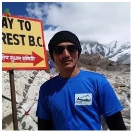
The Everest Region is the world's most celebrated trekking destination, attracting thousands of adventurers each year to the heart of Nepal's Khumbu Valley. Home to Mount Everest (8,848.86 m), Sagarmatha National Park, ancient Sherpa settlements, high-altitude glaciers, and some of the Himalayas' most iconic trekking routes, the region offers far more than a journey to Everest Base Camp. Trekkers can explore diverse landscapes ranging from rhododendron forests and alpine meadows to glacial lakes and mountain passes while enjoying panoramic views of Everest, Lhotse, Makalu, Cho Oyu, Ama Dablam, and other legendary Himalayan peaks.
The Everest Region combines world-class mountain scenery with rich Sherpa culture, well-established trekking infrastructure, and routes suitable for both first-time Himalayan trekkers and experienced high-altitude adventurers. From choosing the best trekking season and understanding altitude challenges to comparing trekking routes, costs, permits, accommodation, safety considerations, and cultural experiences, the region provides one of the most complete trekking experiences on Earth. Understanding these factors helps trekkers select the right itinerary and prepare for a safe, rewarding, and unforgettable Himalayan adventure.
What Makes the Everest Region One of the World's Best Trekking Destinations?
The Everest Region earns its global status through 4 overlapping strengths: unmatched Himalayan scenery, living Sherpa culture, well-developed trail infrastructure, and extreme geographic diversity across elevations ranging from 2,800 metres to 8,848.86 metres. These elements combine to create a trekking experience that no other destination replicates.
Why Is the Everest Region Famous Among Trekkers?
The Everest Region is famous because it delivers the world's highest mountain as a visual and physical objective. Trekkers walk to Everest Base Camp at 5,364 metres, a milestone that requires no technical climbing skills yet places you at the foot of the most celebrated mountain in human history.
Beyond the summit ambition, the region's fame rests on 5 concrete factors:
-
Scale of the peaks: 4 of Nepal's 8 eight-thousanders are visible from trails in this region
-
Cultural authenticity: Sherpa communities in villages like Namche Bazaar, Khumjung, and Pangboche maintain centuries-old Buddhist traditions
-
Trekking infrastructure: 300+ tea houses and lodges operate throughout the Khumbu Valley, making logistics straightforward for independent trekkers
-
Sagarmatha National Park: a 1,148 km² protected wilderness area that has held UNESCO World Heritage status since 1979
-
Year-round accessibility: 3 of the 4 seasons (spring, autumn, and winter) support active trekking with proper preparation
What Natural Landscapes Can You Experience in the Everest Region?
The Everest Region presents 5 distinct landscape zones as elevation increases:
-
Subtropical valley forests (2,800–3,500 m): Rhododendron and pine forests dominate the lower Dudh Koshi valley, particularly vivid during April and May
-
Alpine meadows and glacier moraines (3,500–4,500 m): Open grasslands around Dingboche and Lobuche reveal unobstructed views of Ama Dablam, Nuptse, and Pumori
-
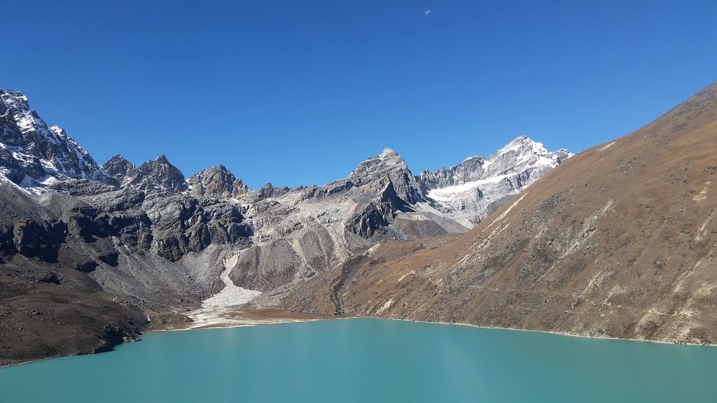
High-altitude lakes (4,700–5,000 m): The 6 Gokyo Lakes sit within a glacial system fed by the Ngozumpa Glacier, Nepal's longest glacier at 36 kilometres
-
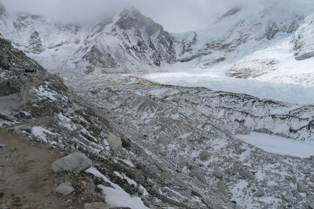
Glacial terrain and icefalls (5,000–5,500 m): The Khumbu Icefall towers directly above Base Camp, a dynamic mass of ice that shifts daily
-
Permanent snowfields and summit zones (5,500 m+): Reserved for mountaineers with expedition permits, these zones are visible from trekking trails across the region
What Cultural Experiences Make the Everest Region Unique?
The Sherpa people define the cultural identity of the Everest Region. Ethnically Tibetan in origin, Sherpas migrated to the Khumbu Valley approximately 500 years ago and developed a distinct culture centred on Tibetan Buddhism, high-altitude agriculture, and trans-Himalayan trade.
Trekkers encounter 4 direct cultural experiences on the trails:
-
Buddhist monasteries at Tengboche (3,867 m), Pangboche (3,930 m), and Thame (3,820 m) host active monk communities and Mani Rimdu festival celebrations in October and November
-
Mani walls and prayer flags line every major trail; spinning prayer wheels at village entrances is a traditional greeting act
-
Sherpa home visits in teahouses provide firsthand accounts of expedition history, including stories linking local families to every major Everest ascent since 1953
-
Dumje and Losar festivals fall in summer and winter, respectively, and both draw entire village communities into communal ceremonies visible to trekkers present during those periods
What Are the Main Trekking Routes in the Everest Region?
The Everest Region offers 6 established trekking routes, ranging from the 12-day Everest Base Camp Trek to the 20-day Three Passes circuit. Each route targets a different combination of altitude, difficulty, and scenic priority.
What Is the Everest Base Camp Trek?
The Everest Base Camp Trek is the most popular Himalayan trek in the world. The route runs from Lukla (2,860 m) through Namche Bazaar (3,440 m), Tengboche (3,867 m), Dingboche (4,410 m), and Lobuche (4,940 m) before reaching Everest Base Camp at 5,364 metres.
The standard itinerary covers 130 kilometres over 12–14 days. Kala Patthar at 5,545 metres serves as the highest viewpoint on this route, providing a direct, overhead line-of-sight to Everest's summit. The descent back to Lukla follows the same trail, with a flight back to Kathmandu completing the journey.
What Is the Gokyo Lakes Trek?
The Gokyo Lakes Trek targets the Gokyo Valley, a route that diverges from the Everest Base Camp trail at Namche Bazaar and heads northwest toward the Dudh Pokhari lake system. The trek reaches Gokyo Ri at 5,357 metres, a summit that delivers a panoramic view of 4 eight-thousanders simultaneously: Everest (8,848.86 m), Lhotse (8,516 m), Makalu (8,485 m), and Cho Oyu (8,188 m).
This route takes 12–14 days and attracts trekkers seeking lower crowding levels, superior lake scenery, and glacier proximity without the commercial intensity of the Base Camp trail.
What Is the Three Passes Trek?
The Three Passes Trek is the most technically demanding standard trekking route in the Everest Region. It crosses 3 high mountain passes: Renjo La at 5,360 m, Cho La at 5,420 m, and Kongma La at 5,535 m. The route loops through both the Gokyo Valley and the Everest Base Camp approach, visiting Gokyo, Thangnak, Dzongla, Lobuche, and Chhukung.
The complete circuit covers 170–190 kilometres over 18–20 days and requires trekkers to be physically fit, experienced at altitude, and prepared for glacier crossing on the Cho La section.
What Other Popular Treks Are Available in the Everest Region?
4 additional trekking options exist within the Everest Region beyond the 3 primary routes:
-
Pikey Peak Trek (4,065 m): A 7-day lower-altitude option in the Solu area offering the widest panoramic view of Everest accessible below 5,000 metres
-
Jiri to Everest Base Camp Trek: a classic overland approach that became popular with trekkers seeking a longer, more gradual ascent through lower Sherpa villages.” The 1953 British Everest expedition went from Kathmandu into the Khumbu and reached Thyangboche; Jiri was not their original approach
-
Ama Dablam Base Camp Trek: A 10-day route to the base of the 6,812-metre peak widely described by mountaineers as the most aesthetically perfect mountain in the Himalayas
-
Chola and Renjo La Trek: A 14-day moderate circuit crossing 2 passes while avoiding the Kongma La crossing, suitable for trekkers with less experience on high glacial terrain
What Can You See During a Trek in the Everest Region?
A trek through the Everest Region presents mountain views of 4 peaks above 8,000 metres, 12+ Sherpa villages, the 1,148 km² Sagarmatha National Park wildlife ecosystem, and 5 active Buddhist monasteries. The visual and cultural richness accumulates with every day of walking.
Which Mountains Are Visible Along the Trails?
The Everest Region trail network reveals 4 eight-thousanders from multiple angles and distances:
|
Mountain |
Elevation |
Visible From |
|
Mount Everest |
8,848.86 m |
Kala Patthar, Gokyo Ri, Renjo La |
|
Lhotse |
8,516 m |
Kala Patthar, Chhukung Ri |
|
Makalu |
8,485 m |
Gokyo Ri, Chhukung Ri |
|
Cho Oyu |
8,188 m |
Gokyo Ri, Renjo La |
Ama Dablam at 6,812 metres remains the most photographed peak on the Everest Base Camp trail, visible from the Tengboche ridge for 3 consecutive trekking days.
Which Sherpa Villages Are Worth Visiting?
6 Sherpa villages stand out for cultural significance and altitude variety:
-
Namche Bazaar (3,440 m): The regional commercial centre with weekly Saturday markets, bakeries, gear shops, and the Sherpa Culture Museum documenting 500 years of local history
-
Khumjung (3,790 m): Home to a school Edmund Hillary built in 1961 and a monastery housing a preserved scalp claimed to belong to a Yeti
-
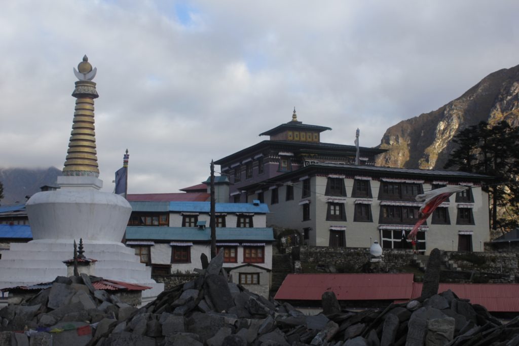
Tengboche (3,867 m): Location of the largest monastery in the Khumbu region, framed by a direct Everest and Ama Dablam backdrop
-
Pangboche (3,930 m): one of the most historically important villages in the Khumbu, with an old monastery and strong Sherpa cultural traditions
-
Dingboche (4,410 m): A classic acclimatisation stop featuring stone-walled potato and barley fields at one of the highest cultivated elevations in Nepal
-
Gorak Shep (5,164 m): The last permanent settlement before Everest Base Camp, with a small lodge cluster serving as the overnight stop before the Base Camp approach
What Wildlife and National Park Attractions Can You Explore?
Sagarmatha National Park hosts 118 bird species and 28 mammal species within its protected boundaries. Trekkers commonly observe:
-
Himalayan tahr: a large goat-antelope species frequently visible on rocky slopes above Namche Bazaar
-
Snow leopard: present in the park but rare to sight; most encounters occur above 4,500 metres during winter
-
Red panda: inhabits the lower rhododendron forests between Lukla and Namche Bazaar
-
Musk deer: frequently spotted in forest corridors near Phakding and Monjo
-
Danphe (Himalayan Monal): Nepal's national bird, recognisable by iridescent plumage, seen on open hillsides year-round
The park also contains 4 important glacial systems: the Khumbu, Ngozumpa, Lhotse, and Imja glaciers. Imja Glacial Lake has expanded to 1.8 km in length since the 1960s, a measurable marker of high-altitude climate change.
Which Monasteries and Cultural Sites Should You Visit?
5 key cultural sites carry historical and spiritual significance for trekkers:
-
Tengboche Gompa: Annual Mani Rimdu festival in November draws monks from across the Khumbu for 3 days of masked dances and community prayer
-
Pangboche Lower Monastery: Founded approximately 350 years ago and considered the oldest in the Khumbu; contains original murals and 400-year-old artefacts
-
Thame Monastery: Located off the main trail, this site is where Lama Sangwa Dorje, the founding spiritual figure of the Khumbu Sherpa community, meditated in the 17th century
-
Khumjung Monastery: Holds the disputed Yeti scalp and maintains active pujas attended by village elders on auspicious lunar calendar days
-
Chortens at Namche and Lobuche: The memorial chortens above Lobuche honour climbers who died on Everest expeditions; over 40 plaques cover the stone structures
When Is the Best Time to Visit the Everest Region?
The 2 optimal seasons for Everest Region trekking are spring (March to May) and autumn (September to November). Both seasons deliver stable weather, clear mountain views, and open mountain passes.
How Does Spring Compare With Autumn?
Spring and autumn each hold distinct advantages across 4 key factors:
|
Factor |
Spring (Mar–May) |
Autumn (Sep–Nov) |
|
Weather stability |
High; pre-monsoon windows |
Very high; post-monsoon clarity |
|
Crowds |
Moderate to high (April peak) |
Highest (October peak) |
|
Rhododendron bloom |
Full bloom March–April |
None |
|
Mountain clarity |
Good; occasional high haze |
Excellent; sharpest visibility |
April is the single most popular trekking month in the region, driven by rhododendron forests in full red and pink bloom below 4,000 metres. October delivers the clearest skies and the highest number of trekkers on the trail simultaneously.
Can You Trek During Winter?
Winter trekking in the Everest Region operates from December through February. The 3 practical realities of winter trekking are:
-
Temperature: Night-time temperatures at Base Camp drop to -20°C; Namche Bazaar averages -10°C overnight in January
-
Pass closures: The Three Passes Trek becomes inaccessible after heavy snowfall, typically from mid-December onward
-
Lodge availability: 60–70% of high-altitude lodges close in January and February; Namche Bazaar and Tengboche remain reliably open year-round
The benefit of winter trekking is near-complete solitude below 4,500 metres. Trekkers with proper cold-weather gear and an experienced guide from Nepal Intrepid Treks complete the Everest Base Camp route in winter without technical obstacles below the pass zones.
Is the Monsoon Season Suitable for Trekking?
Monsoon season runs from June through August. Trekking during the monsoon presents 3 consistent challenges: trail mud and landslide risk below 3,500 metres, reduced mountain visibility due to cloud cover, and higher rates of leeches on lower forest trails.
The Everest Region lies in Nepal's rain shadow at elevations above 4,000 metres, meaning Namche Bazaar and above typically receive clear mornings even during peak monsoon months. The Gokyo Valley and the upper Khumbu receive significantly less rainfall than the lower Dudh Koshi valley during this period.
How Difficult Is Trekking in the Everest Region?
The Everest Base Camp Trek rates as moderately difficult, requiring 5–7 hours of daily walking at altitudes between 3,000 m and 5,545 m over 12–14 consecutive days. The Three Passes Trek escalates to strenuous difficulty, demanding glacier crossing experience and high-altitude fitness.
What Fitness Level Is Required?
A trekker completing the Everest Base Camp route needs to sustain 15–20 km of walking per day on steep, uneven terrain. Pre-trek preparation focused on 3 training areas produces the highest success rates:
-
Cardiovascular endurance: 8–12 weeks of running, cycling, or stair training at 45–60 minutes per session, 4 times per week
-
Leg strength: Weighted step-up exercises and downhill running to prepare quadriceps and knees for extended descents
-
Load-bearing practice: 4–6 training hikes with a 10–12 kg backpack to simulate daily trekking pack weight
Trekkers who train for 10–12 weeks before departure usually improve endurance, confidence, and comfort on the trail.
How Does High Altitude Affect Trekkers?
High altitude reduces oxygen availability by approximately 50% at 5,000 metres compared to sea level. The body responds through 4 physiological adaptations:
-
Increased breathing rate: Respiratory rate doubles at altitude to compensate for lower oxygen partial pressure
-
Elevated heart rate: Resting heart rate rises by 10–20 beats per minute during the first 3 days at a new elevation
-
Reduced sleep quality: Periodic breathing (Cheyne-Stokes respiration) disrupts sleep at elevations above 3,500 metres
-
Appetite suppression: Reduced gastric motility at altitude decreases hunger signals, making caloric intake a discipline requirement rather than an automatic response
Acute Mountain Sickness (AMS) affects approximately 50% of trekkers who ascend to 4,500 metres without proper acclimatisation. Symptoms include persistent headache, nausea, dizziness, and fatigue, all of which resolve with descent or acclimatisation rest days.
How Can You Prepare for the Trek?
Preparation across 4 domains reduces both AMS risk and trekking difficulty:
-
Physical training: Follow the 10–12 week cardiovascular and strength programme described above
-
Altitude medication: Acetazolamide (Diamox) can help prevent acute mountain sickness for some trekkers, but dosage and suitability should be confirmed with a clinician before use
-
Gear selection: Layer clothing system appropriate for -15°C overnight temperatures; test all gear during at least 2 full training hikes before departure
-
Mental preparation: Accept rest days as non-negotiable parts of the itinerary, not wasted time; the acclimatisation rest day at Namche Bazaar on day 3 directly determines summit success rates at higher elevations
How Safe Is Trekking in the Everest Region?
The Everest Region is a safe trekking destination when proper acclimatisation protocols, licensed guides, and standard equipment standards are followed. The primary safety risks are altitude sickness, weather-related trail conditions, and physical injury on steep terrain.
What Are the Common Risks?
5 specific risks account for the majority of trekking incidents in the Everest Region:
-
Acute Mountain Sickness (AMS): The most frequent health issue; progresses to High Altitude Pulmonary Edema (HAPE) or High Altitude Cerebral Edema (HACE) in severe untreated cases
-
Hypothermia: Occurs when trekkers underestimate night-time temperature drops; preventable with proper layering
-
Dehydration: High respiration rates at altitude increase fluid loss significantly; 3–4 litres of water per day is the baseline requirement above 4,000 metres
-
Ankle and knee injuries: Steep rocky descents from Kala Patthar and the Cho La pass account for most musculoskeletal injuries; trekking poles reduce this risk substantially
-
Flight cancellations at Lukla: Tenzing-Hillary Airport (IATA: LUA) operates under strict visual flight rules. Weather conditions at Lukla Airport can cause flight delays or cancellations, particularly during periods of unstable weather. Trekkers are advised to include extra buffer days in their itinerary.
How Can You Prevent Altitude Sickness?
Altitude sickness prevention follows the "climb high, sleep low" principle. 4 concrete prevention strategies form the standard protocol used by Nepal Intrepid Treks guides on every itinerary:
-
Ascend no more than 300–500 metres in sleeping elevation per day above 3,000 metres
-
Take mandatory acclimatisation rest days: at minimum, 1 full rest day at Namche Bazaar (3,440 m) and 1 at Dingboche (4,410 m)
-
Hydrate consistently: 4 litres of water per day is non-negotiable above Namche Bazaar
-
Recognise early AMS symptoms: Persistent headache after rest and hydration at a given altitude is the key indicator to stop ascending and rest or descend
The standard Golden Rule of altitude trekking: descend immediately if symptoms worsen after 24 hours of rest at the same elevation. Descent of 500–1,000 metres resolves virtually all AMS, HAPE, and HACE symptoms within 12–24 hours.
What Emergency Services Are Available?
3 emergency response systems operate within the Everest Region:
-
Helicopter rescue: Helicopter rescue services are available throughout the Everest Region when weather conditions permit. Actual response times vary depending on location, visibility, aircraft availability, and operational conditions
-
Himalayan Rescue Association (HRA) clinics: Permanent medical posts at Namche Bazaar (3,440 m) and Pheriche (4,371 m) provide altitude-illness assessment and oxygen treatment year-round
-
Satellite communication: Nepal Intrepid Treks guides carry satellite phones and personal locator beacons (PLBs) on all organised treks for real-time emergency communication in areas without mobile coverage
How Long Does an Everest Region Trek Take?
Standard Everest Region treks range from 7 days (short-form Pikey Peak) to 20 days (Three Passes circuit), with the classic Everest Base Camp Trek requiring 12–14 days from Lukla. Total trip duration including Kathmandu arrival, departure buffer, and Lukla flights is 14–22 days for most itineraries.
How Many Days Does the Everest Base Camp Trek Require?
The Everest Base Camp Trek requires a minimum of 12 days from Lukla for trekkers who are physically prepared and acclimatise on schedule. The standard 14-day itinerary breaks down as follows:
|
Day |
Destination |
Elevation |
|
1 |
Lukla → Phakding |
2,610 m |
|
2 |
Phakding → Namche Bazaar |
3,440 m |
|
3 |
Namche Bazaar (acclimatisation) |
3,440 m |
|
4 |
Namche → Tengboche |
3,867 m |
|
5 |
Tengboche → Dingboche |
4,410 m |
|
6 |
Dingboche (acclimatisation) |
4,410 m |
|
7 |
Dingboche → Lobuche |
4,940 m |
|
8 |
Lobuche → Gorak Shep → EBC |
5,364 m |
|
9 |
Gorak Shep → Kala Patthar → Pheriche |
5,545 m → 4,371 m |
|
10 |
Pheriche → Namche Bazaar |
3,440 m |
|
11 |
Namche → Lukla |
2,860 m |
|
12 |
Lukla → Kathmandu (flight) |
1,400 m |
Which Shorter Trekking Options Are Available?
4 shorter alternatives deliver Everest Region experiences under 10 days:
-
Namche Bazaar Trek (5 days): Reaches 3,440 m with Everest viewpoint hike to Everest View Hotel at 3,880 m; ideal for first-time high-altitude visitors
-
Tengboche Trek (7 days): Adds the monastery and Ama Dablam viewpoint to the Namche route; maximum elevation 3,867 m
-
Pikey Peak Trek (7 days): Lower altitude alternative through Solu region with wide-angle Everest panorama; maximum elevation 4,065 m
-
Jorsalle to Namche Day Trek: A single-day excursion from Lukla to Namche Bazaar and back, accessible as a day itinerary for guided group clients based in Lukla
Which Longer Trekking Adventures Can You Choose?
3 extended trekking routes exceed the standard EBC duration:
-
Three Passes Trek (18–20 days): Crosses Renjo La, Cho La, and Kongma La; the most comprehensive Khumbu circuit available
-
Jiri to Everest Base Camp Trek (20–22 days): Begins with road transfer to Jiri (1,905 m) and follows the original 1953 expedition approach; adds 8–10 days of lower-altitude Sherpa village trekking
-
Everest Base Camp and Island Peak Climb (18–20 days): Combines EBC with a technical ascent of Island Peak (Imja Tse) at 6,189 metres; requires ice axe and crampon skills taught during a 2-day pre-summit training session
How Much Does Trekking in the Everest Region Cost?
A guided Everest Base Camp Trek package with a reputable Nepal trekking company costs USD 1,200–1,800 per person for a 12–14 day trip from Kathmandu. Total costs including international flights, gear, and travel insurance range from USD 3,000–5,000 for most international trekkers.
What Factors Affect Trek Costs?
6 variables directly determine total Everest Region trek expenditure:
-
Guided vs. independent: Guided packages include permits, accommodation, meals, and guide fees; independent trekking saves USD 400–600 but requires self-managing all logistics
-
Season: October peak season accommodation in Namche Bazaar costs USD 15–25 per night; off-season rates drop to USD 5–10
-
Group size: Larger groups (6+ trekkers) receive 10–20% discounts on guided package rates
-
Duration: Each additional day adds approximately USD 80–120 per person for guided itinerary extensions
-
Helicopter vs. flight entry: Lukla flights from Kathmandu cost USD 180–220 per leg; helicopter charters cost USD 600–900 per segment
-
Teahouse vs. camping: Teahouse trekking (standard) averages USD 30–50 per day for food and accommodation combined; camping expeditions cost USD 70–100 more per day
What Is Included in a Typical Trekking Package?
A standard Nepal Intrepid Treks guided package includes:
-
Domestic flights (Kathmandu–Lukla–Kathmandu)
-
Sagarmatha National Park entry permit (NPR 3,000 for foreigners, NPR 1,500 for SAARC nationals, and NPR 100 for Nepali citizens)
-
Khumbu Pasang Lhamu Rural Municipality Entry Permit
-
Licensed, English-speaking trekking guide
-
Porter service (1 porter per 2 trekkers, standard ratio)
-
Teahouse accommodation (twin-sharing basis)
-
3 meals per day on trek
-
Welcome and farewell dinners in Kathmandu
-
First aid kit and emergency communication equipment
Items not typically included: international flights, travel insurance, personal gear, beverages, Wi-Fi fees at lodges, tips for guides and porters, and costs associated with unplanned extra acclimatisation days.
How Can You Budget for an Everest Region Trek?
A realistic total budget breakdown for an international trekker completing the 14-day EBC route:
|
Budget Category |
Estimated Cost (USD) |
|
Guided trek package (from KTM) |
1,200–1,800 |
|
International flights (round-trip) |
700–1,200 |
|
Travel insurance (trek-specific) |
150–300 |
|
Gear and equipment |
300–700 |
|
Kathmandu (pre/post, 4 nights) |
150–300 |
|
Personal spending on trek |
100–200 |
|
Total estimated range |
2,600–4,500 |
Budget trekkers who own core gear, travel in a group, and book 3–4 months in advance complete this trip at the lower end of this range consistently.
What Should You Pack for an Everest Region Trek?
Essential packing for the Everest Region covers 3 categories: layered cold-weather clothing system, trekking equipment, and permit documents. Total pack weight for teahouse trekking targets 10–12 kg in the main duffel and 5–7 kg in the day pack.
Which Clothing Is Essential?
The layering system for Everest Base Camp consists of 3 clothing layers designed for conditions ranging from +15°C at Namche Bazaar midday to -20°C at Gorak Shep at night:
-
Base layer: 2 moisture-wicking thermal long-sleeve tops and 1 pair thermal leggings (merino wool or synthetic)
-
Mid layer: 1 fleece jacket and 1 down jacket (600+ fill power minimum) for warmth above 4,000 metres
-
Outer layer: 1 waterproof, windproof shell jacket and shell trousers for weather protection
-
Extremities: Insulated waterproof trekking boots, wool hiking socks (4–5 pairs), liner gloves, insulated outer gloves, and a thermal hat covering ears
Which Trekking Gear Should You Bring?
9 items of trekking equipment are non-negotiable on the Everest Region trail:
-
Trekking poles (collapsible, with ergonomic grip)
-
Headlamp (300+ lumens) with spare batteries
-
Sleeping bag rated to -15°C (available for rental in Kathmandu at USD 1–2 per day)
-
Water purification (purification tablets or UV SteriPen)
-
Sunscreen (SPF 50+) and UV-blocking glacier sunglasses
-
First aid kit including blister treatment, ibuprofen, anti-diarrhoeal medication, and Diamox
-
Duffel bag (80–100 litre) for porter transport of main gear
-
Day pack (25–30 litre) for daily walking essentials
-
Portable battery bank (20,000 mAh minimum) for device charging between lodges
Which Documents and Permits Are Required?
3 documents are mandatory for all trekkers entering the Everest Region:
-
Khumbu Pasang Lhamu Rural Municipality Permit: Issued locally in Lukla or at the Monjo checkpoint; costs NPR 2,000 (~USD 15) per person. (Note: The TIMS card is no longer required for Everest Region trekking)
-
Sagarmatha National Park Permit: NPR 3,000 for foreigners, NPR 1,500 for SAARC nationals, and NPR 100 for Nepali citizens, and they can be obtained at the Nepal Tourism Board counter in Kathmandu or at the park entrance gate at Monjo.
-
Valid passport: Carry the original document throughout the trek; photocopies are not accepted at checkpoints
Should You Trek Independently or Hire a Guide?
Hiring a licensed guide from Nepal Intrepid Treks provides measurable advantages in safety, cultural access, logistical efficiency, and altitude illness management over independent trekking. Independent trekking is physically possible but removes 3 critical safety layers.
What Are the Benefits of Hiring a Guide?
A licensed Everest Region guide provides 6 direct services that independent trekkers cannot replicate:
-
AMS monitoring: Trained guides administer daily Lake Louise Score assessments to detect early altitude sickness before symptoms escalate
-
Route knowledge: Off-trail navigational errors on the Three Passes Trek have caused fatalities; guides eliminate this risk entirely
-
Emergency coordination: Guides initiate helicopter evacuation, contact family members, and manage all medical paperwork in an emergency
-
Cultural access: Local Sherpa guides translate interactions at monasteries and village homes into genuine cultural exchanges rather than transactional tourism
-
Permit management: Guides handle all checkpoint paperwork, reducing daily administrative burden and preventing permit-related trail access denials
-
Local network: Established relationships with lodge owners guarantee accommodation during the October peak season, when independent trekkers frequently find lodges full above Namche Bazaar
When Is a Porter Worth Hiring?
A porter is worth hiring when the trekker's duffel bag exceeds 10 kg. Responsible trekking operators generally limit porter loads to approximately 20–25 kg to support fair working conditions and porter welfare. Porters cost USD 20–30 per day, inclusive of their food, accommodation, and insurance: the most cost-effective safety investment on any Everest Region itinerary.
Trekkers who carry full packs independently report 3 consistent negative outcomes: faster AMS onset due to increased physical exertion, knee pain on steep descents, and reduced capacity to respond to unexpected weather delays with extra gear.
Can You Trek the Everest Region Without a Guide?
Trekking rules in Nepal change over time, so confirm the current permit and guide requirements for the exact route before departure.” A 2023 rule change required guides/porters on many treks, while 2026 reporting says Nepal later loosened solo-travel access for some previously restricted routes, so the blanket sentence is too broad. The trail to Everest Base Camp is well-marked with clear signage in English and Nepali throughout the Sagarmatha National Park boundary.
The 3 practical limitations of guideless trekking are: inability to access real-time AMS medical assessment from trained professionals, no emergency communication backup independent of mobile networks (which fail above 4,000 m on non-NCell towers), and no cultural interpretation during monastery and village interactions. Independent trekkers accept these limitations in exchange for schedule flexibility and cost reduction of USD 400–600 over a 14-day itinerary.
Who Is the Everest Region Best Suited For?
The Everest Region suits trekkers in 4 distinct categories:
-
First-time Himalayan trekkers: The Everest Base Camp route's teahouse infrastructure and well-marked trails make it the most accessible introduction to high-altitude trekking globally
-
Experienced mountain trekkers: The Three Passes Trek and Island Peak combination provide sufficient physical and technical challenge for trekkers with 5+ years of high-altitude experience
-
Cultural travellers: The Sherpa village network, Buddhist monastery circuit, and Saturday market at Namche Bazaar deliver a living cultural immersion unmatched in the Himalayan range
-
Photographers and visual storytellers: The concentration of iconic peaks (Everest, Ama Dablam, Lhotse, Nuptse) within daily walking distance from teahouse accommodation creates 14 consecutive days of world-class photographic opportunity
The Everest Region is not suited for trekkers with uncontrolled cardiac conditions, severe respiratory conditions, or those unwilling to follow mandatory acclimatisation protocols. Pre-trek medical clearance from a physician is recommended for all trekkers above 55 years of age.
How Can You Plan the Best Everest Region Trek With Nepal Intrepid Treks?
Nepal Intrepid Treks designs Everest Region itineraries based on 3 client-specific inputs: fitness level, available trip duration, and trekking objective (summit views, cultural depth, or technical challenge). Every itinerary includes built-in acclimatisation days, licensed Sherpa guides, and emergency response protocols that eliminate the 3 primary risks facing independent trekkers in the Khumbu.
Can Nepal Intrepid Treks Help You Choose the Right Everest Region Trek?
Nepal Intrepid Treks offers 6 Everest Region routes calibrated to different experience levels and time windows. The consultation process matches each trekker to the correct route based on previous high-altitude experience, preferred daily walking duration, and group composition.
Trekkers who contact Nepal Intrepid Treks with a target date and fitness background receive a customised itinerary within 24 hours, complete with daily elevation profiles, accommodation confirmations, and permit cost breakdowns. The team's guides are certified by the Nepal Mountaineering Association and have accumulated a combined total of over 300 Everest Base Camp ascents across the past 15 years of operation.
What Are the Key Takeaways About the Everest Region?
The Everest Region delivers 7 definitive qualities that justify its rank as the world's premier trekking destination:
-
Highest altitude accessible without technical climbing: Kala Patthar at 5,545 m and Everest Base Camp at 5,364 m are reachable on foot by any well-prepared, healthy adult
-
Unmatched mountain concentration: 4 of the world's 14 eight-thousanders (Everest, Lhotse, Makalu, and Cho Oyu) are spectacularly visible from standard trekking trails.
-
Living cultural heritage: The Sherpa Buddhist community maintains 500 years of Khumbu cultural tradition across 12 active villages and 5 functioning monasteries
-
Year-round accessibility: Spring, autumn, and winter each support trekking with proper preparation; only full monsoon months present consistent trail challenges below 4,000 m
-
Scalable difficulty: Routes range from 7-day, sub-4,000 m options to 20-day technical pass crossings, serving all experience levels
-
Robust safety infrastructure: Helicopter rescue, HRA medical clinics, and licensed guide networks provide 3 independent safety layers unavailable in less-developed trekking regions
-
Information gain over competing destinations: No other trekking region on Earth combines this altitude, biodiversity, cultural density, and trail accessibility within a single valley system
The Everest Region is not simply a trek to the world's highest mountain. It is a 12–20 day immersion into one of the most geographically and culturally concentrated environments on Earth. Planning with Nepal Intrepid Treks ensures every day on the trail is structured for both safety and maximum experience.