Mount Everest is the highest mountain on Earth above sea level, rising 8,848.86 meters (29,031.7 feet) along the border of Nepal and Tibet in the Himalayas. Known as Sagarmatha and Chomolungma, Everest is the highest peak in the Mahalangur Himal and the defining summit of the Himalayan mountain system. Formed by the collision of the Indian and Eurasian tectonic plates around 50 million years ago, the mountain continues rising through tectonic uplift while anchoring one of Earth’s most extreme alpine climates, glacier systems, and high-altitude ecosystems.
Everest is also one of the most significant mountains in human history, linking exploration, science, religion, and survival. The summit became globally famous after the 1953 ascent by Edmund Hillary and Tenzing Norgay, while the surrounding Khumbu region remains central to Sherpa culture, Buddhist traditions, and modern expedition tourism. From the Death Zone above 8,000 meters to the Khumbu Icefall, Everest represents the intersection of mountaineering, climate change, geological research, and cultural heritage, making it far more than the world’s tallest peak.
What Makes Mount Everest the World's Highest Mountain?
Mount Everest is the world's highest mountain because its summit reaches 8,848.86 meters above mean sea level, the greatest elevation of any point on Earth's surface. This designation uses sea level as the universal baseline. Two competing metrics exist: height above sea level (where Everest wins) and distance from Earth's center (where Mount Chimborazo in Ecuador wins, due to the planet's equatorial bulge).
Everest holds its "highest" title under the globally accepted standard used by the Survey of India, China's National Administration of Surveying, Mapping and Geographic Information, and every major geographical authority. The mountain's position deep within the Himalayan orogeny, the geological event that built the tallest mountain system on Earth, places it in a category no other peak matches.
Where Is Mount Everest Located?
Mount Everest lies in Solukhumbu District, Koshi Province, Nepal, bordering Tingri County in Tibet Autonomous Region, China, at coordinates 27.9881° N, 86.9250° E. “Sagarmatha Zone” is a former administrative division abolished under Nepal’s federal restructuring. Its summit lies precisely on the international boundary line, which makes the mountain jointly administered in terms of climbing permits, base camps, and national jurisdiction.
The nearest major city is Kathmandu, Nepal, located approximately 130 kilometers southwest of the mountain. Lhasa, Tibet, lies roughly 600 kilometers to the northeast. The mountain's remoteness within the Khumbu region of northeastern Nepal places it beyond road access; trekkers reach Everest Base Camp via a multi-day walk from Lukla, an airstrip town at 2,860 meters altitude.
Which Countries Share Mount Everest?
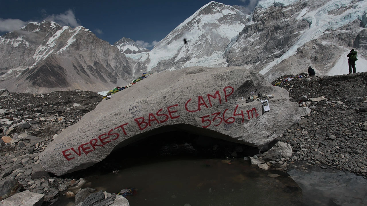
Nepal and China (via the Tibet Autonomous Region) both claim sovereign territory on Mount Everest. Nepal controls the southern face, which hosts the South Base Camp at 5,364 meters and the popular Southeast Ridge route. China controls the northern face, which hosts the North Base Camp at 5,150 meters and the Northeast Ridge route.
The 1961 Boundary Treaty between Nepal and China formally defined the borderline passing through the summit. Both countries issue independent climbing permits. A Nepal permit costs USD 15,000 per climber for the spring season (2026 rate). A Tibet permit costs approximately USD 9,000, though China periodically closes the northern routes for political or logistical reasons, as it did during the 2020 and 2021 COVID-19 period.
How Does the Himalayas Range Shape Everest's Geography?
The Himalayan range, stretching 2,400 kilometers across South Asia, creates the high-altitude plateau environment that isolates Everest from lower-elevation weather systems and supports its extreme vertical relief. Everest belongs to the Mahalangur Himal sub-range, a cluster that also includes 4 of the world's 14 peaks above 8,000 meters: Lhotse (8,516 m), Makalu (8,485 m), and Cho Oyu (8,188 m) all sit within 50 kilometers of Everest.
The Tibetan Plateau to the north acts as a thermal engine, generating the monsoon systems that control Everest's weather from June through September. The Khumbu region on the southern flank receives 1,000–1,500 millimeters of annual precipitation, most of it during the monsoon. This atmospheric geography defines the 2 viable climbing windows per year.
How Tall Is Mount Everest?
.webp)
Everest's official height is 8,848.86 meters (29,031.7 feet) above sea level, as determined by a joint survey conducted by China and Nepal in 2020. This measurement replaced the 1954 Survey of India figure of 8,848 meters and the 1999 National Geographic Society GPS measurement of 8,850 meters. Nepal and China jointly announced an orthometric height of 8,848.86 m for Sagarmatha, based on GNSS, levelling, gravity observations, and a regional geoid tied to the International Height Reference System.
How Has Everest's Official Height Changed Over Time?
Everest's recorded height has changed 5 times since systematic measurement began in the 19th century:
1856: Survey of India calculated 8,840 meters using trigonometric calculations from 6 observation stations across the Gangetic Plain.
1955: Revised Survey of India measurement set the figure at 8,848 meters, the number used globally for 65 years.
1999: National Geographic Society and Boston Museum of Science GPS survey returned 8,850 meters, though this was never universally adopted.
2005: China measured 8,844.43 meters by calculating the rock height beneath the snow cap, a methodological difference that caused diplomatic tension with Nepal.
2020: China and Nepal jointly announced the definitive 8,848.86 meters figure, measured using GNSS satellite systems, gravimetric data, and snow-depth radar. This ended the two-country dispute and set the current globally accepted standard.
The Nepal Survey Department paper identifies trigonometric levelling, precise levelling, GNSS survey, gravity survey, airborne gravity data, and surface gravity data as components of the measurement program.
Why Is Measuring Everest's Height So Difficult?
Everest's height is difficult to measure precisely because its summit holds a snow and ice cap of variable depth, atmospheric refraction distorts trigonometric observations, and the geoid (the mathematical shape of Earth's sea-level surface) underneath the Himalayas is irregular.
The 2020 joint survey addressed all 3 problems. Teams placed GNSS receivers directly on the summit to eliminate trigonometric errors. Gravimetric instruments measured the local geoid undulation, the difference between the mathematical ellipsoid and true sea level, which can vary by several meters in mountain regions. A 4 May 2022 1,000 MHz ground-penetrating-radar survey collected 57 traces and found an average summit snow depth of about 9.5 m with ±1.2 m uncertainty across 26 summit points. Without removing this variable, different measurement epochs produce different results.
How Was Mount Everest Named?
Mount Everest was named after Sir George Everest in 1865 by the Royal Geographical Society, based on a recommendation by Andrew Waugh, the British Surveyor General of India. Waugh designated the peak "Peak XV" during the Great Trigonometrical Survey of India and later proposed naming it after his predecessor when no single local name could be confirmed.
Who Was Sir George Everest?
Sir George Everest (1790–1866) was a Welsh surveyor and geographer who served as Surveyor General of India from 1830 to 1843. He oversaw the completion of the Great Arc, a geodetic survey measuring 2,400 kilometers of the Indian subcontinent from the southern tip to the Himalayan foothills. This survey laid the mathematical foundation that allowed his successor Andrew Waugh to identify and calculate the height of Peak XV (later named Everest) from observation stations 200 kilometers away.
Everest himself never visited the Himalayas and reportedly objected to having the mountain named after him, partly because his name could not be easily pronounced in Hindi or Urdu, a practical concern for a peak within South Asia. The Royal Geographical Society overruled this concern and formalized the name on March 23, 1865.
What Do Local Communities Call Everest?
The 2 primary local names for Everest are Sagarmatha in Nepali and Chomolungma (also spelled Qomolangma) in Tibetan. Both names predate the British designation by centuries.
Sagarmatha translates to "Goddess of the Sky" or "Forehead in the Sky" in Nepali. The name gained formal international recognition when Nepal established Sagarmatha National Park in 1976, a UNESCO World Heritage Site covering 1,148 square kilometers around the mountain.
Chomolungma translates to "Goddess Mother of the World" or "Holy Mother" in Tibetan. Tibetan maps from as early as the 18th century use this name. The Chinese government officially uses Qomolangma on all state maps, and the northern base camp carries this designation.
Local Sherpa communities use Chomolungma and consider the mountain a living deity, not a resource or destination, a perspective that fundamentally shapes how Sherpa guides and high-altitude workers engage with expeditions.
How Was Mount Everest Formed?
Mount Everest formed through the collision of the Indian tectonic plate and the Eurasian tectonic plate, a process that began approximately 50 million years ago and continues to the present day. The collision zone produced the Himalayan mountain range, with Everest as its highest expression.
How Did Tectonic Plates Create Everest?
The Indian plate, moving northeast at 5 centimeters per year, collided with the stationary Eurasian plate and subducted beneath it, forcing the crust upward into fold mountains. The Himalayas represent the most dramatic example of continent-continent collision on Earth's current surface. Where oceanic crust collides with continental crust, the oceanic plate subducts cleanly. The Indian-Eurasian collision involved two continental plates, both too buoyant to subduct fully, producing extreme crustal thickening and the Tibetan Plateau, the largest and highest plateau on Earth at an average elevation of 4,500 meters.
Marine limestone and sedimentary rock deposits from the ancient Tethys Sea, an ocean that once separated India from Eurasia, appear in Everest's summit zone above 8,600 meters. Fossils of marine organisms have been collected from these summit rocks, direct evidence that the current highest point on Earth once lay beneath an ocean floor.
Why Is Everest Still Growing?
Everest grows approximately 4 millimeters per year due to continued northward movement of the Indian plate, though glacial erosion and isostatic adjustment partially offset this uplift. According to the Geological Society of America, net uplift rates in the central Himalaya range from 1 to 5 millimeters per year depending on erosion rates at each specific location.
A 2023 study published in Nature Geoscience identified an additional growth mechanism: the Kosi River system, which drains the southern Himalayan slopes, captures and removes material rapidly, reducing the weight pressing down on the underlying crust. This process, called isostatic rebound, contributes roughly 0.5 millimeters of additional annual height gain specific to the Everest massif, more than previously accounted for in standard tectonic models.
What Is the Climate Like on Mount Everest?
Everest experiences one of Earth's most extreme climate profiles: temperatures ranging from –36°C (–33°F) at Base Camp in winter to –19°C (–2°F) at the summit on the warmest days, with wind speeds regularly exceeding 200 kilometers per hour at the summit during winter jet stream positioning.
How Cold Does Everest Get?
The coldest recorded temperature near the Everest summit is approximately –60°C (–76°F), measured during winter months when the polar jet stream sits directly over the peak. At Base Camp (5,364 meters), average January temperatures reach –17°C (1°F) and drop to –36°C (–33°F) at night. The summit averages –19°C in May, the warmest month and primary climbing season, but wind chill regularly pushes the effective temperature below –40°C during storms.
Why Are Weather Conditions So Dangerous on Climbers?
3 specific weather phenomena make Everest conditions uniquely lethal: the jet stream, sudden storm formation, and white-out visibility. The polar jet stream positions itself directly over the Himalayas from October through April, generating winds above 160 km/h at the summit with no warning. The jet stream shifts briefly northward in May, creating the 2–3 week summit window that most expeditions target.
Sudden storms form when warm, moist air from the Bay of Bengal collides with cold air masses descending from the Tibetan Plateau. These storms deposit 1–2 meters of new snow in 24 hours, triggering avalanches and making retreat impossible. The 1996 Everest disaster, which killed 8 climbers in a single day, resulted directly from an unexpected storm that trapped 2 guided expeditions on the Southeast Ridge above 7,900 meters.
Why Is Climbing Mount Everest So Challenging?
Climbing Everest is challenging because 3 compounding hazards converge above 8,000 meters: severe oxygen deprivation, extreme cold that impairs judgment and motor function, and objective terrain dangers including avalanches, crevasses, and knife-edge ridges. No other mountain on Earth combines all 3 at the same scale.
What Makes the Altitude So Dangerous?
At Everest's summit (8,848.86 m), atmospheric pressure is approximately 33% of sea-level pressure, meaning each breath delivers one-third the oxygen available at sea level. The human body's physiological response to this hypoxic environment, the "death zone" above 8,000 meters, includes impaired cognitive function, loss of fine motor control, and accelerated development of high-altitude pulmonary edema (HAPE) or high-altitude cerebral edema (HACE), both of which are fatal if untreated.
How Does Thin Air Affect Climbers?
Thin air at Everest's altitude triggers 5 measurable physiological responses in climbers: reduced arterial oxygen saturation, increased breathing rate, disrupted sleep due to Cheyne-Stokes respiration, decreased appetite causing caloric deficit, and impaired decision-making from cerebral hypoxia.
Acclimatization, the process of ascending gradually to allow red blood cell production to increase, reduces but does not eliminate these effects. The standard acclimatization schedule for an Everest expedition takes 6–8 weeks, with climbers making 3 acclimatization rotations between Base Camp and Camp III (7,162 m) before attempting the summit.
How Do Climbers Reach the Summit?
Climbers reach Everest's summit via one of 2 primary routes: the Southeast Ridge from Nepal and the Northeast Ridge from Tibet, supported by a fixed rope and camp system established at the start of each expedition season.
What Are the Main Climbing Routes?
The Southeast Ridge (South Col Route) and the Northeast Ridge (North Col Route) are the 2 established Everest summit routes. The Southeast Ridge was first climbed by Edmund Hillary and Tenzing Norgay in 1953 and remains the most popular route, used by approximately 75% of all summit attempts. Key features include the Khumbu Icefall (between Base Camp and Camp I), the Western Cwm (Camp I to Camp II), the Lhotse Face (Camp II to Camp III), and the Southeast Ridge from Camp IV (South Col, 7,906 m) to the summit. Visitors who want a less-trafficked perspective on the same massif often combine their itinerary with the Gokyo Lake Trek, which approaches Everest from the west via six turquoise glacial lakes and the panoramic Gokyo Ri viewpoint.
The Northeast Ridge from Tibet accesses the summit via the North Col (7,028 m), the North Face traverse, and the famous "Three Steps", rocky outcrops at 8,563 m, 8,570 m, and 8,600 m that require technical climbing at extreme altitude.
When Is the Best Season to Climb Everest?
The 2 viable Everest climbing seasons are pre-monsoon spring (April–May) and post-monsoon autumn (September–October). Spring is overwhelmingly preferred: warmer temperatures, longer daylight hours, and the temporary northward shift of the jet stream create a summit window of 5–15 days in May. Understanding the best season to climb Everest also informs trekkers planning lower-altitude Khumbu trips, since the same weather windows govern Base Camp access. Autumn offers clearer skies but colder temperatures and a shorter, less predictable weather window.
Winter ascents (December–February) and monsoon attempts are possible in theory but have been achieved only by a handful of elite mountaineers due to consistent jet stream winds above 200 km/h and whiteout storm conditions.
What Equipment Is Needed to Climb Everest?
A complete Everest summit attempt requires 40–60 individual equipment items across 4 categories: clothing and insulation, climbing hardware, oxygen systems, and survival gear. The total gear weight carried personally by a climber above Camp II averages 15–20 kilograms, excluding oxygen cylinders.
Why Is Supplemental Oxygen Often Used?
Supplemental oxygen is used on Everest because breathing ambient air at the summit produces arterial oxygen saturation levels of 50–70%, below the threshold required for sustained physical exertion and safe decision-making. Standard flow rates range from 1 liter per minute during sleep to 4 liters per minute during the summit push. At 4 L/min, a single 3-liter cylinder at 300 bar lasts approximately 4–5 hours, requiring climbers to carry 3–4 cylinders for a summit day.
Climbers who ascend without supplemental oxygen, termed "alpine style" or "without Os", represent fewer than 5% of all summiteers. The 41 recorded no-oxygen ascents as of 2024 require climbers to have exceptional prior acclimatization and a VO2 max sufficient to sustain movement at near-zero oxygen partial pressure.
What Safety Gear Is Essential?
6 categories of safety equipment are non-negotiable on Everest: fixed-line ascending systems (jumar/ascender), crampons rated for steep ice, high-altitude boots insulated to –60°C, avalanche transceivers above Camp II, a personal locator beacon, and a pre-loaded dexamethasone injection kit for HACE/HAPE emergencies. Dexamethasone, a corticosteroid, reduces cerebral swelling and buys approximately 12 hours of function in a climber developing HACE, sufficient time to descend to a lower camp.
Who First Reached the Summit of Mount Everest?
Edmund Hillary of New Zealand and Tenzing Norgay, a Sherpa from Nepal, first reached the summit of Mount Everest on May 29, 1953, at 11:30 AM local time, as part of the British Expedition led by Colonel John Hunt. Hillary spent approximately 15 minutes on the summit, took photographs of Norgay and the surrounding peaks, and searched for evidence of a prior summit attempt by George Mallory and Andrew Irvine.
How Did Edmund Hillary and Tenzing Norgay Succeed?
The 1953 British Expedition succeeded where 15 prior expeditions failed by applying 3 systematic improvements: purpose-built closed-circuit oxygen sets developed by Alf Bridge and Griffith Pugh, a deliberate acclimatization program designed by physiologist Griffith Pugh, and a logistical supply chain involving 362 porters and 20 Sherpa guides. The oxygen systems delivered a constant 3 L/min flow, eliminating the equipment failures that plagued earlier expeditions. The acclimatization schedule gave Clinton and Wilfrid Noyce time to establish Camp IX at 8,504 m, a high camp that reduced summit day duration from 12+ hours to under 8.
What Historic Expeditions Changed Everest Climbing?
4 expeditions fundamentally changed Everest climbing history:
1953 (British Expedition): First summit. Proved human survival at 8,849 m is physiologically possible.
1963 (American Everest Expedition): First traverse, Tom Hornbein and Willi Unsoeld ascended via the West Ridge and descended the Southeast Ridge, proving alternate routes existed.
1975 (Japanese Women's Expedition): Junko Tabei became the first woman to summit Everest, expanding the pool of potential summiteers and demonstrating that the mountain was not exclusively a men's pursuit.
1978 (Habeler and Messner): Peter Habeler and Reinhold Messner summited without supplemental oxygen, disproving the scientific consensus that the human body could not survive at the summit without artificial oxygen.
What Risks Do Climbers Face on Everest?
Climbers on Everest face 4 primary categories of risk: altitude illness (HAPE, HACE, AMS), objective terrain hazards (avalanches, crevasses, rockfall), weather-induced exposure, and human error compounded by cognitive impairment from hypoxia. According to the Himalayan Database, 339 climbers have died on Everest between 1922 and 2026, a death rate of approximately 1.1% per summit attempt overall, though the rate drops to under 0.5% for commercially guided expeditions using supplemental oxygen.
What Is the Death Zone?
The Death Zone is the altitude band above 8,000 meters where the human body consumes more oxygen than the ambient environment provides, creating a net physiological deficit regardless of rest or acclimatization. At 8,000 m, atmospheric pressure is 35% of sea level. The human brain begins deteriorating within minutes of severe hypoxia. No climber can survive extended periods in the Death Zone without descending or using supplemental oxygen, the body deteriorates regardless of prior fitness level.
Why Are Avalanches and Icefalls So Dangerous?
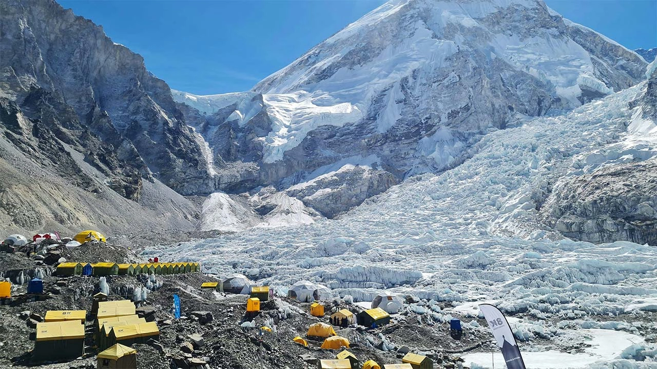
The Khumbu Icefall, a 600-meter section between Base Camp (5,364 m) and Camp I (5,943 m), is statistically the most dangerous section of the Southeast Ridge route. The icefall is a moving glacier that advances 1 meter per day, continuously shifting seracs (ice towers weighing thousands of tons) and collapsing snow bridges over crevasses. Experienced mountaineers who want to test their skills in this terrain before a full summit attempt often start with Lobuche Peak climbing, a 6,119 m trekking peak in the Khumbu that offers genuine high-altitude technical experience alongside panoramic Everest views. The 2014 Khumbu Icefall avalanche killed 16 Sherpa guides in a single event, the deadliest single incident in Everest history to that date.
Avalanche risk extends above the icefall: the 2015 Nepal earthquake triggered an avalanche from Pumori that struck Base Camp, killing 22 people, the deadliest Everest disaster on record.
How Has Tourism Changed Mount Everest?
Commercial Everest expeditions, which began in 1985 when guide Dick Bass summited as the first paying client, transformed the mountain from an elite mountaineering objective to an accessible (though expensive) aspiration for thousands of people globally. Today, travelers who want Khumbu views without the 14-day commitment can opt for a short trek to Everest, reaching dramatic high-altitude landscapes in a condensed itinerary. In 2026, Nepal issued 492 summit permits, the highest annual number ever recorded, generating USD 5.27 million in permit fees for the Nepalese government.
The waste-management study reports approximately 60,000 tourists in 2019, compared with 20 in 1964, 3,200 in 1973, about 5,000 per year in 1980, about 20,000 in 1998, and about 30,000 per year from 2006–2015.
Why Has Everest Become Commercialized?
3 developments drove Everest's commercialization: guided expedition companies offering complete logistics, improved equipment and oxygen systems reducing technical barriers, and international media coverage amplifying the cultural cachet of summiting. Rob Hall's Adventure Consultants and Scott Fischer's Mountain Madness, both active in the fatal 1996 season, pioneered the model of charging USD 65,000 (1996 value) for a full guiding service. Current commercial expedition prices range from USD 30,000 to USD 100,000+ depending on service level and guiding team.
What Problems Has Crowding Created?
Crowding on Everest creates 3 measurable problems: bottlenecks at technical sections that extend summit day duration by 2–4 hours (increasing exposure risk), accelerated waste accumulation, and "social pressure summiting" where climbers continue despite deteriorating conditions because others around them are ascending. The infamous photograph from May 2019 showing hundreds of climbers queued on the Southeast Ridge Hillary Step went viral and triggered Nepal's subsequent permit reforms, including proposed experience requirements and a cap on annual permits.
What Environmental Issues Affect Mount Everest?
Everest faces 3 escalating environmental threats: accelerating glacial retreat driven by climate change, accumulated human waste from 70+ years of expedition activity, and deforestation in lower-altitude support zones. The Sagarmatha National Park authority, Nepal's Department of National Parks and Wildlife Conservation, and multiple international NGOs coordinate ongoing environmental management.
How Is Climate Change Impacting Everest?
According to a 2022 study published in npj Climate and Atmospheric Science, Everest's South Col Glacier, the glacier that feeds the Khumbu Icefall, has lost ice equivalent to 2,000 years of natural accumulation in the past 25 years. Rising temperatures have shifted the snow-ice boundary (the freezing line) approximately 180 meters higher in elevation since 1989, exposing bare rock on slopes that previously remained glaciated year-round. Warmer temperatures increase avalanche frequency by accelerating ice melt that destabilizes seracs, directly worsening the hazard climbers face in the Khumbu Icefall.
Why Is Waste Management a Growing Concern?
Waste management on Everest is a growing concern because approximately 50 metric tons of waste, including human excrement, oxygen cylinders, ropes, tents, and food packaging, accumulate on the mountain annually. Nepal's "Carry Me Back" regulation (2014) requires each climber to bring back 8 kilograms of waste from above Base Camp. The Eco Everest Expedition and the Sagarmatha Next initiative have collectively removed over 24 metric tons of legacy waste since 2008.
Human waste is a particular problem above Camp II, where frozen excrement deposited over decades partially thaws as temperatures rise, contaminating meltwater used by climbers and threatening downstream water supplies used by communities in the Khumbu Valley. The Nepali government implemented a waste deposit system in 2023 requiring teams to leave USD 4,000 in a refundable deposit, recovered only upon verified waste return.
Why Is Mount Everest Important to Local Culture?
Mount Everest holds irreplaceable spiritual, economic, and identity significance for the 3,500 Sherpa people living in the Khumbu region of northeastern Nepal. For Sherpa communities, Everest is not a geographical record, it is Chomolungma, a living deity central to their Tibetan Buddhist cosmology, cultural identity, and ancestral land rights.
How Do Sherpa Communities View Everest?
Sherpa people view Everest as a sacred mother goddess whose permission is required before each climbing season. The Puja ceremony, performed at Base Camp before every expedition departs, involves a Buddhist lama conducting prayers, burning juniper branches, and blessing climbing equipment. Expedition members, regardless of their personal religious beliefs, participate out of respect. Sherpa guides who skip the Puja before ascending are considered by the community to invite misfortune, and most reputable guide companies include the ceremony as a mandatory pre-climb ritual.
The Sherpa relationship with Everest is also economic: high-altitude guiding income accounts for a primary revenue source in a region where agricultural options are limited by altitude. A senior Sherpa guide earns USD 5,000–10,000 per expedition season, compared to a national Nepali per-capita income of approximately USD 1,337 annually (World Bank, 2023).
Why Is Everest Sacred in Regional Traditions?
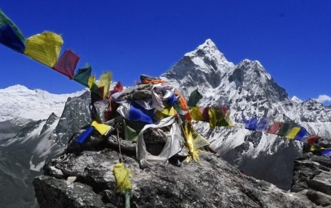
Everest holds sacred status in both Tibetan Buddhism and the Bon religious tradition of the Tibetan Plateau, the pre-Buddhist spiritual system that predates Buddhism's arrival in Tibet by centuries. In Tibetan Buddhist cosmology, Chomolungma is one of 5 "Long-Life Sisters" (Tsheringma), goddesses believed to reside in the 5 highest peaks of the Himalayas. Ritual offerings, prayer flags, and stone cairns placed by Sherpa and Tibetan pilgrims at the mountain's base reflect centuries of devotional practice unconnected to climbing.
The mountain's UNESCO World Heritage designation as part of Sagarmatha National Park (1979) formally acknowledges both its natural and cultural significance, a dual recognition that fewer than 50 sites worldwide hold.
How Should You Explore Mount Everest Beyond Climbing?
Exploring Everest beyond technical climbing is accessible through several pathways: trekking to Everest Base Camp, joining research or conservation expeditions, cultural immersion in Sherpa communities of the Khumbu Valley, and for those with limited time, an Everest helicopter tour that delivers high-altitude panoramas of the Khumbu massif within a single day. Full summit attempts require years of mountaineering experience, USD 30,000–100,000 in expedition costs, and extensive prior high-altitude climbing credentials. Base Camp trekking requires none of these.
Can Trekking to Everest Base Camp Offer the Experience?
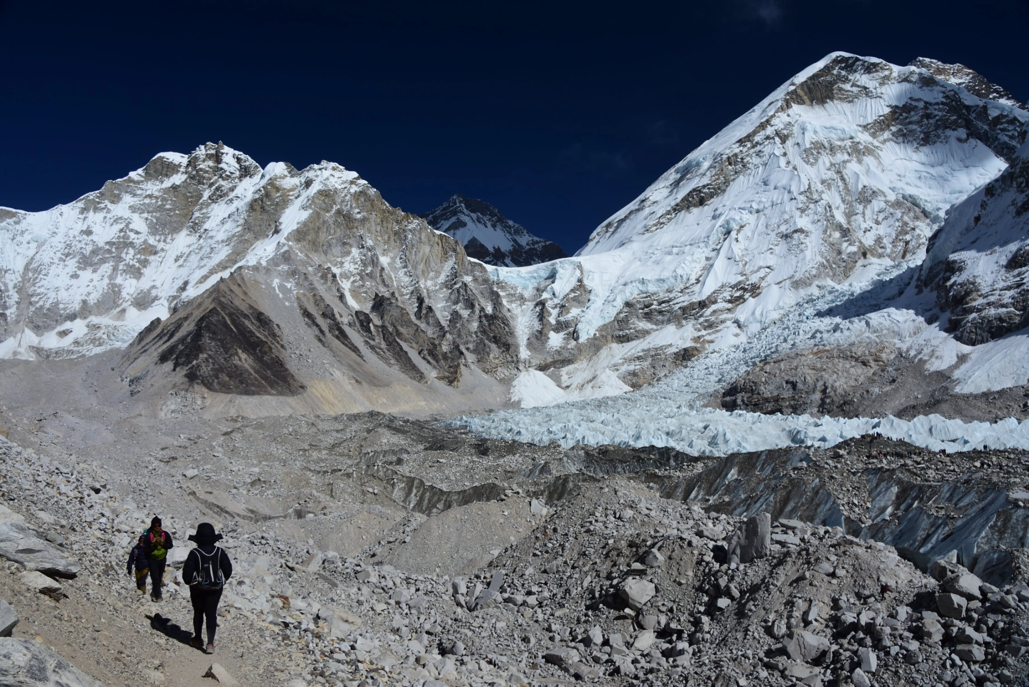
The Everest Base Camp trek to 5,364 m on the South Col Route offers direct views of the Khumbu Icefall, Nuptse (7,861 m), and the southern Everest summit pyramid without technical climbing. The trek covers 130 kilometers round-trip from Lukla and takes 12–16 days at a pace designed for safe acclimatization. Altitude sickness remains a risk: approximately 30–40% of trekkers experience mild AMS symptoms, and 5% require descent or medical attention.
Key stops on the Base Camp trek include Namche Bazaar (3,440 m), the Sherpa cultural capital and trekking hub, Tengboche Monastery (3,867 m), and Kala Patthar (5,645 m), a viewpoint that provides the most photographed panoramic view of Everest's summit available without technical equipment.
What Are the Key Takeaways About Mount Everest We Covered?
Mount Everest is simultaneously a geological record, a cultural icon, an extreme environment, and a human testing ground. The core facts to retain:
Height: 8,848.86 meters above sea level, officially confirmed by China and Nepal in 2020 using GNSS and gravimetric survey methods.
Location: On the Nepal-Tibet (China) border within the Mahalangur Himal sub-range of the Himalayas, at 27.9881° N, 86.9250° E.
Formation: Created by the collision of the Indian and Eurasian tectonic plates approximately 50 million years ago; still growing at approximately 4 mm per year.
First summit: Edmund Hillary and Tenzing Norgay, May 29, 1953, via the Southeast Ridge.
Climbing risks: The Death Zone above 8,000 m, Khumbu Icefall avalanches, and sudden weather changes account for the majority of the 318 deaths recorded through 2024.
Environmental pressures: Glacier retreat accelerated by climate change and 50 metric tons of annual waste accumulation represent the 2 most urgent threats to the mountain's long-term ecology.
Cultural status: Chomolungma (Tibetan) and Sagarmatha (Nepali) are names rooted in centuries of Sherpa and Tibetan Buddhist tradition that frame the mountain as a living deity, not a destination.
Everest rewards depth of understanding. Whether you plan to trek its lower slopes, study its geology, or simply want to understand why this particular peak commands global fascination, the mountain's story spans tectonics, history, physiology, culture, and ecology in ways few natural features on Earth can match. For travelers who want to experience the Khumbu in comfort, the Everest luxury trek offers private lodge accommodation, gourmet meals, and a helicopter return, blending high-altitude adventure with five-star amenities.